Scientific Framework
1. What has lived in the oceans?
2. What does live in the oceans?
3. What will live in the oceans?
The Census consisted of four major component programs organized around these questions.
Investigating the Past
Census researchers undertook the challenge of constructing the history of marine animal populations since human predation became important, roughly the last 500 years. This program component was called History of Marine Animal Populations (HMAP).
Teams of fisheries scientists, historians, economists and others conducted case studies in southern Africa, Australia, and approximately a dozen other regions. Together, these case studies created the first reliable picture of life in the oceans before fishing. This depiction of a more pristine ocean has proved helpful in setting goals for marine protection. The long historical records of marine populations help distinguish the contributions of natural fluctuations in the environment from the effects of human activities.
Assessing the Present
The largest component of the Census involved investigating what now lives in the world's oceans through 14 field projects. Each sampled important kinds of biota in one of six realms of the global oceans using a range of technologies. Details of these interesting and varied field projects are provided below.
Forecasting the Future
To speak about what will live in the oceans required numerical modeling and simulation. This component program was organized under the rubric of the Future of Marine Animal Populations (FMAP). This group focused on integrating data from many different sources and creating new statistical and analytical tools to predict marine populations and what the composition of ecosystems might be in the future.
Together, the historical, present, and predictive programs of the Census aimed to improve what is known about life in the oceans, to identify what is unknown but knowable, and what may be unknowable.
Providing a Living Legacy
Such a global initiative required a state-of-the-art data assimilation framework, and this effort, the Ocean Biogeographic Information System (OBIS), formed the fourth component program of the Census. OBIS realized the vision of users being able to click on maps of the oceans on their laptops or desktops anywhere in the world and bring up Census data on what had been reported to live in their ocean zone of interest. By the end of 2010, OBIS contained more than 30 million records of species locations throughout the global ocean, and will live on as a component of the UNESCO International Oceanographic Commission's program, the International Oceanographic Data and Information Exchange.
Six Ocean Realms
To successfully undertake a task as massive as a global census of marine life, the oceans were divided into six realms (with respective sub-zones as necessary), and the Census field projects developed efficient approaches for the exploration of each.
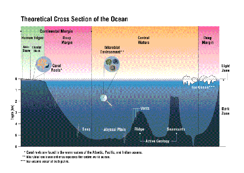
The realms were intended to encompass all major ocean systems and taxa and were selected to take advantage of the best available technologies. In all Realms, the Census sought to representatively document diversity. In near surface waters it tackled distribution, and along the human edges it demonstrated best practices to estimate abundance. However, recognizing that over 95% of the more than 30 million geographic species records in OBIS were from less than 100 meter depths, it became clear that a quantitative census of all Realms was 'unknowable' in even such an ambitious ten-year program.
The realms are described below.
1. Human Edges
The continental shelves are very gradually sloping borders between the edges of continents and ocean basins. While the shelves comprise only 10 % of ocean areas, they contain most of the known marine biodiversity and lie mainly within the exclusive economic zones of nations. For purposes of the Census, these "Human Edges", from the high tide line to the bottom of the continental shelf, were divided into nearshore and coastal zones.
Nearshore Zone
The Census defined the nearshore as the region between the high tide line and 10 meters water depth. The accessible nearshore area has been studied in minute detail in many locales around the world. The nearshore, however, stretches for more than a million kilometers around all oceans and across latitudes and climates. Testing nearshore ecological hypotheses required that researchers used similar methods in nearshore areas across all latitudes, climates, and ecosystems. This linkage was accomplished in the field project Natural Geography in Shore Areas (NaGISA - "coastal environment" in Japanese). NaGISA's goal was to assess, visualize, and explain nearshore biodiversity patterns.Coral reefs were another nearshore system investigated by Census researchers. The global Census of Coral Reefs (CReefs) field project is national (Australia, USA), regional (Caribbean), and international in scope. Researchers were linked across latitudes and climates with standardized research methods for studying the complex habitats created by corals, analogous to those of NaGISA, to assess, visualize, and explain diversity patterns before such patterns are further affected by global changes.
Coastal Zone
One coastal field project, the Gulf of Maine Area Program (GoMA) was designed to identify and collect the biological knowledge necessary for ecosystem-based management in a large marine environment. GoMA integrated policy and science perspectives and represented a bi-national collaboration between the Canadian Department of Fisheries and Oceans (DFO) and the U.S. National Oceanic and Atmospheric Administration (NOAA). Both governments shared costs and data to create the Gulf of Maine Biogeographic Information System (GMBIS).Another coastal project was the Pacific Ocean Shelf Tracking Project (POST). Its goal was to build a permanent acoustic tracking array for juvenile Pacific salmon and other species as small as 10 g along the west coast of North America, which now serves as a prototype for other coasts. POST's legacy is that it served as a prototype for the Ocean Tracking Network, which is under construction.
2. Hidden Boundaries
The Census investigated regions for which there was little prior biological data. The slope region of continental margins that begins at the edge of the continental shelf and extends to ocean basins were considered in the Hidden Boundaries category because they are difficult to sample and were little studied.
The deep sea floor below the base of the continental slope covers 30% of the Earth's surface, more than the total continental area (29%). This region, from approximately 4000 to 6000 meters in water depth, has large areas of flat plains and is called the abyssal plain. Ridges and rises often confine these plains. If the ridge or rise is high enough to prevent the exchange of water with surrounding basins, the deep dwelling marine life there is isolated. Very little was known about life in the abyssal plain regions. Hence, they were included in the Hidden Boundaries realms.
Slope Zone
The Census project, Continental Margin Ecosystems (COMARGE) established biodiversity baselines in margin areas worldwide, focusing on those still untouched by commercial exploitation. COMARGE collected evidence of changes from commercial activities in the vast Slope Zone, and determined the slope's role in the evolution and distribution of species in continental margin zones above and below.Valuable synergy existed between COMARGE participants and interests of other Census field projects, including those related to hydrothermal vents, the deep sea, and microbes. Collectively, these efforts helped identify and describe many new species that were discovered in this poorly studied realm. Since the major interest in and access to the Slope Zone stems from oil exploration, the initial focus was on benthic ecology and diversity.
Abyssal Plain
The Census of Diversity of Abyssal Marine Life (CeDAMar) was launched to study abyssal plain biodiversity of the endo-, epi-, and hyperbenthic organisms (those living in, on or directly above the sediment). CeDAMar successfully unified significant Abyssal Plain projects in major ocean basins. Its taxonomists gathered data on species assemblages of single ocean basins and on the large-scale distribution of species. CeDAMar established standardized sampling protocols for the study of deep-sea biodiversity. Its databases will serve as a benchmark well into the future.
3. Central Waters
The ocean basins and open deep water are between the continental margins. This region was characterized by the Census as Central Waters. These large open ocean areas are home to at least 40% of the world's primary production of biomass. The Census divided the Central Waters into the Light Zone, from the ocean surface to 200 m water depth, and the Dark Zone, from 200 m to the ocean floor.
Light Zone (drifters and swimmers)
The focus of study on organisms that drift in the Light Zone was whether this community is consistent globally. This investigation required molecular tools and global assessment of populations throughout the ocean. In contrast, there was no question about the basin-wide or even global connections among the large swimming pelagic animals in the Light Zone. New technologies are making it possible to provide realistic estimates of the global distribution and abundance in this realm. Although many of the tracked species also spend time in the Dark Zone, they were categorized in the Light Zone realm where they typically feed.The Census of Marine Zooplankton (CMarZ) was undertaken to accomplish global-scale analysis of all marine zooplankton groups using new and emerging technologies including molecular, optical, and acoustical imaging, and remote detection. Efforts focused on DNA barcoding of existing specimen collections to identify cryptic species among cosmopolitan groups. CMarZ strove to complete a taxonomically comprehensive assessment of animal plankton biodiversity throughout the world ocean.
At the other end of the spectrum was the Tagging of Pacific Predators (TOPP), which used marine animals to create a view of vast open ocean habitats as seen by the animals themselves, especially top predators. Knowing the behavior of the top predators allowed inferences about the distribution and abundance of many other organisms that live in the ocean, such as where prey species accumulate. By the end of the Census in 2010, TOPP had produced a unique, integrated overview of open ocean biology in the Pacific and enhanced knowledge about marine life in other parts of the global ocean.
Dark Zone (mid-water and bottom-water)
The challenge of investigating the Dark Zone was taken on by a multi-national group of researchers who formed the Mid-Atlantic Ridge Ecosystems Project (MAR-ECO). The objective of MAR-ECO was to explore and understand the distribution, abundance, and trophic (feeding) relationships of the organisms inhabiting the middle and deep waters of the mid-oceanic North Atlantic, and to identify and model ecological processes that cause variability in these patterns. By the end of 2010, MAR-ECO had provided a wealth of information enhancing understanding of the species, communities and ecosystems of the Mid-Atlantic Ridge and associated waters and set a technological example for other regions.
4. Active Geology
Seamounts, hydrothermal vents, and cold seeps are geologically active areas, grouped together in the Active Geology realm. The Census project, Biogeography of Deep-Water Chemosynthetic Ecosystems (ChEss), was launched to discover new hydrothermal vents and cold seeps, to assess the diversity, distribution, and abundance of their fauna in relation to other chemosynthetic ecosystems, and to explain the differences and similarities at the global scale. By the end of its decadal investigation, ChEss had substantially increased the number of known vents and seeps, discovered new species in chemosynthetic environments, and entered assessments of their new and known species diversity, distribution, and abundance into the OBIS database. Beyond these contributions, ChEss bequeathed its example and methods for effective international assessment and explanation of marine life in a specific realm.
The project focused on seamounts, Census of Seamounts (CenSeam) synthesized known biodiversity and helped direct future field efforts toward a comparative ecology of seamounts. The most efficient sampling strategies and additional existing data resources were brought into the SeamountsOnline database. The roles seamounts play in the biogeography, biodiversity, productivity, and evolution of marine organisms and their effect on the global oceanic ecosystem was clarified and quantified by the Census' end in 2010.
5. Ice Oceans - Arctic and Antarctic
Two Census field projects were designed to study ocean areas at opposite poles of the Earth. Each shared a need for specially equipped ice breaking ships, forcing highly integrated sampling schedules for the entire water column from surface ice to abyssal plains. The first Ice Ocean field project launched was Arctic Ocean Diversity (ArcOD). Its goal was to assemble existing knowledge of biodiversity in the least known ocean, direct new international explorations using new technologies, and create a framework for understanding and predicting biological changes in this rapidly melting ocean. By 2010, data were be available on the biogeography of the Arctic that will serve as a baseline for anticipated climatic changes.
Like its northern counterpart, the Census of Antarctic Marine Life (CAML) assembled rich biological data on the Southern Ocean, and encouraged biodiversity sampling on all cruises in the region, particularly during the focal period of the International Polar Year (IPY 2007-2009). The goal was to couple this new understanding of biology with the complex current dynamics that control gene flow through the world's oceans.
6. Microbes - The Microscopic Ocean
With more than 38,000 different types of organisms in one liter of seawater, the numbers of microbes in marine environments is staggering and they play a dominant role in ocean processes. To complete a census of marine microbial life, the International Census of Marine Microbes (ICOMM) was established to develop a highly resolved biodiversity database for marine microbes and to understand how microbial populations - the oldest life on the planet - evolve, interact, and redistribute on a global scale.